Summiting Mt. Tamalpais: A Bay Area Panorama Adventure
Explore Mt. Tamalpais’ summit trail for unmatched panoramic views of the Bay Area’s urban and natural beauty. This hike blends challenging terrain with breathtaking vistas, making it an essential outdoor adventure for hikers visiting Mill Valley, California.
Start Early for Clear Views
Begin your hike at dawn to avoid afternoon fog and enjoy peaceful trail conditions before peak visitor hours.
Bring Waterproof Layers
Weather on Mt. Tam can switch quickly; pack windbreakers and rain shells even if the forecast is clear.
Hydrate Generously
Carry at least two liters of water per person since streams are unreliable and the climb can be thirsty work.
Wear Durable Footwear
Choose hiking boots or trail shoes with good grip to handle slippery forest floors and rocky outcrops securely.
Summiting Mt. Tamalpais: A Bay Area Panorama Adventure
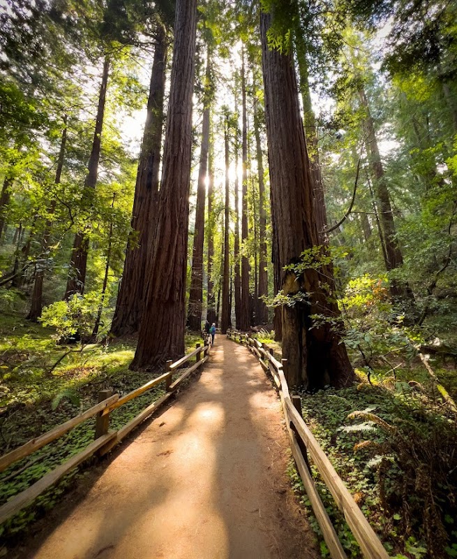
Mt. Tamalpais towers over Mill Valley, its summit a prize for hikers seeking breathtaking 360-degree views of the Bay Area. The trail climbs roughly 2,000 feet over 7 miles round-trip, weaving through fir and madrone trees that stretch their branches toward the sky, daring you onward. The terrain shifts between soft forest mulch and rugged rocky passes, reminding you the mountain is fiercely itself—calling for respect and attention.
Starting at the Palomarin Trailhead, or for a shorter option, from the Mt. Tamalpais East Peak parking area, hikers navigate well-marked paths that wind past creeks whispering underneath mossy bridges. The ascent is steady but manageable, with sections that encourage a steady pace. Along the way, the wind plays its own game, pushing through leaves and guiding your steps.
Reaching the summit reveals sweeping views: San Francisco’s skyline pressing against the horizon like a quiet giant; the Golden Gate Bridge stretching its orange arms across blue waters; the Pacific Ocean rolling beyond the Marin Headlands. On clear days, you can see as far as Mount Diablo to the east and Point Reyes to the north—each peak standing guard over their part of the Bay.
Practical preparation is key. Wear sturdy hiking shoes for traction, pack at least two liters of water, and bring layers—the mountain’s mood can turn quickly, shifting from sun’s embrace to chilly fog within minutes. Early morning hikes reward you with clearer air and peaceful solitude, while late afternoon offers dramatic light for photographers but demands caution as shadows lengthen.
As you descend, take moments to listen: the creeks chuckling over stones, the trees swaying thoughtfully, the buzz of wildlife that calls Mt. Tam home. Hiking Mt. Tamalpais isn’t just a walk; it’s a dialogue with a landscape both wild and welcoming, ready to share its secrets if you’re ready to listen.
Nearby Trips
All Adventures
Boat Charters
Water Activities
Adventures near Mill Valley, California
Discover the unique and memorable adventures that make Mill Valley, California special.
Frequently Asked Questions
How long is the hike to Mt. Tamalpais summit?
The round-trip hike to Mt. Tam’s East Peak summit is about 7 miles, with an elevation gain near 2,000 feet, typically completed in 3 to 5 hours depending on pace.
Is the trail dog-friendly?
Dogs are allowed on most Mt. Tam trails but must be kept on leash to protect local wildlife and other hikers.
Are there restrooms or water sources along the trail?
Restrooms are available at the main parking areas, but there are no reliable potable water sources on the trail, so bring your own.
What wildlife might I see on the hike?
Expect to encounter black-tailed deer, gray foxes, a variety of birds including hawks and woodpeckers, and possibly banana slugs in damp areas.
Is it safe to hike Mt. Tam year-round?
Yes, but trail conditions vary by season. Winter trails can be muddy and slippery, summer afternoons can be hot, and spring may bring rain-soaked ground.
Can I drive to the summit instead of hiking?
Yes, there is a paved road to the East Peak parking lot, which offers easy access to summit views, but hiking offers a fuller experience of the mountain’s ecosystem.
Recommended Gear
Sturdy Hiking Shoes
Provides traction on varied terrain and foot support for ascending rocky slopes.
Water Bottle or Hydration Pack
Maintains hydration during climbs where streams are scarce or unreliable.
Layered Clothing
Allows you to adjust for sudden changes in temperature and wind exposure.
Sun Protection
Hat, sunglasses, and sunscreen guard against intense sun, especially at exposed summits.
Local Insights
Hidden Gems
- "Coastal Trail overlook near Stinson Beach with expansive ocean views."
- "The old railway flare overlook—a small path leading to historic cable car ruins."
- "Rock Spring area—a quiet meadow with native wildflowers in spring."
- "Rocky Ridge Trail segments featuring unexpected glimpses of the Bay."
Wildlife
- "Northern spotted owls, especially active at dusk and dawn."
- "California newts in moist creek beds."
- "Tawny emperor butterflies on sunny clearings."
- "Coyotes heard but rarely seen, particularly in early morning."
History
"Mt. Tamalpais holds significance for the Coast Miwok people, who inhabited the region for thousands of years, using the mountain’s resources sustainably. Later, the mountain became one of California’s early protected parks with rail access dating back to the early 1900s."